Ask anything about a parcel, and what you can actually do with it.
Drop an address, ask what you can build. Parsull reads the parcel and its local code, then tells you what’s actually allowed. Cited, with a real planner one click away.
Trusted by planners, developers & attorneys in all 50 states
Grays Harbor County Planning Dept.
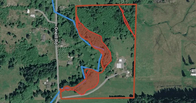
Whether any of the lot is buildable around the floodway and wetland buffers is a discretionary call, so a planner should confirm it.
0s
From address to cited answer
0%
Zoning & code claims cite a source
0 states
Nationwide US coverage
24/7
Always-on research assistant
What it checks
One question screens the whole parcel
Ask once. Parsull checks every critical area and overlay on the parcel, then explains what each means under the controlling jurisdiction’s code, so you know what actually matters, in plain English.
Try it on your addressFrequently flooded & shoreline areas
FEMA flood zones, frequently flooded areas, and proximity to streams and shorelines that trigger riparian buffers, setbacks, and shoreline permits.
Wetlands, habitat & soils
Wetlands, fish and wildlife habitat conservation areas, and soils that affect septic, grading, and SEPA environmental review.
Geologically hazardous areas
Landslide and slope stability, seismic fault proximity, and wildfire exposure, with the engineering, permitting, and insurance implications.
Zoning & authority
Allowed uses, setbacks and overlays, plus whether federal, tribal, or coastal authority overrides local zoning.
Know a parcel
before you commit.
Every critical area, overlay, and zoning rule that touches a property, plus what each means for what you want to build. Answered the moment you ask, with the receipts to prove it.
Capabilities
Everything in one conversation
Ask, attach, speak, escalate. All in a single thread.
Pinpoint the parcel — then what you can build on it
From a raw address to a code-grounded verdict, in one ask.
Pinpoint parcel lookup
Any US address, APN or lat/lng resolved to the exact property — then its governing county, city, and any overriding authority.
Proposed-use analysis
Describe what you want to build. Parsull weighs it against the controlling code and flags permitted, conditional, or prohibited.
Every answer cited — and a real planner one click away
Proof you can open yourself, plus a human for the judgment calls.
Verifiable citations
Every claim links to the source behind it. Open it and confirm the answer yourself.
Human planner escalation
For variances, CUPs and appeals, Parsull finds the right planning department and drafts the question for you to send.
Conversational Q&A
A real back-and-forth about zoning, setbacks and overlays — no jargon required.
Document, map & image uploads
PDFs, Word docs, GeoJSON, site photos or scanned plans, read into the conversation.
Voice input
Speak your question hands-free, on site or between properties.
Saved research threads
Every conversation and document kept as an ongoing project.
Tunable & multilingual
Concise or thorough, imperial or metric, in any of 10 languages.
Who it's for
Built for everyone sizing up a parcel
Developers
Screen entitlement and critical-area risk before you make an offer, in minutes, not weeks.
Land-use attorneys
Pull citation-ready evidence for briefs, appeals, and client advisories.
Municipal planners
Answer public inquiries and prep pre-app meetings with sources on hand.
Agents & PropTech
Add instant critical-area, flood and zoning context to any property workflow.
Stop guessing. Start building.
Bring a parcel and what you want to do with it. Get cited, code-grounded answers that make due diligence simple, and a real planner when you need one.
Research a parcel freeTalk to our team
Rolling Parsull out across a planning department, brokerage, or law firm? Tell us about your volume, jurisdictions, and requirements — and we'll tailor an Enterprise plan that fits.